
History
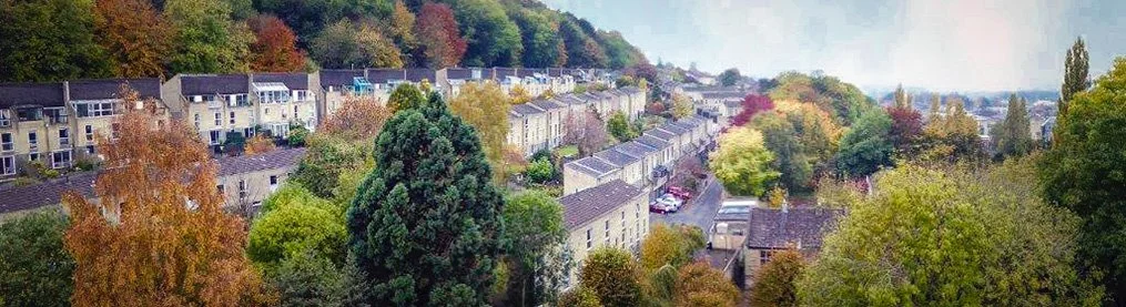
Calton and Holloway
Calton Gardens and Calton Walk
The completion of the Kennet & Avon Canal in 1810 and the GWR railway in 1841 caused the area south of the river to be developed for housing the workers needed to keep Bath running. Development of Calton Road started in the 1830s: first cottages with long gardens extending up the Cliff slope and names like ‘Beautiful View’ were built on the south side, then terraces of small dwellings were built in the 1840s on the north side of the road – Upper Trafalgar Place, St Mark’s Terrace and Beechen Cliff Place.
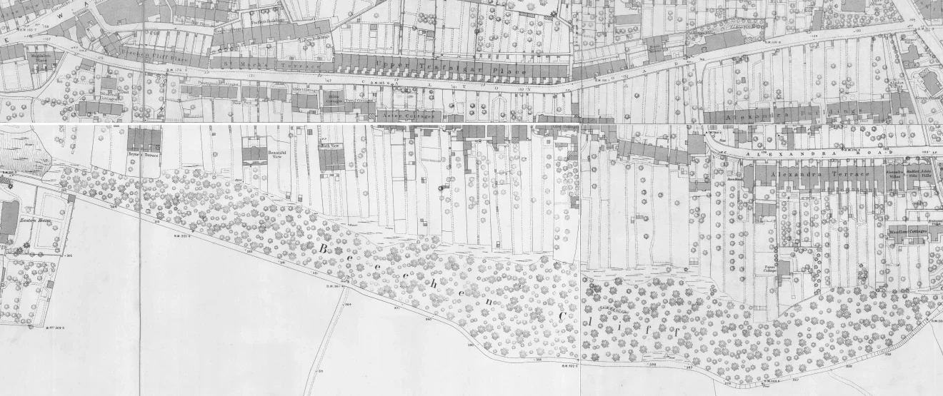
Detail of Calton Road from the 1885 OS map. Courtesy of Bath Record Office.
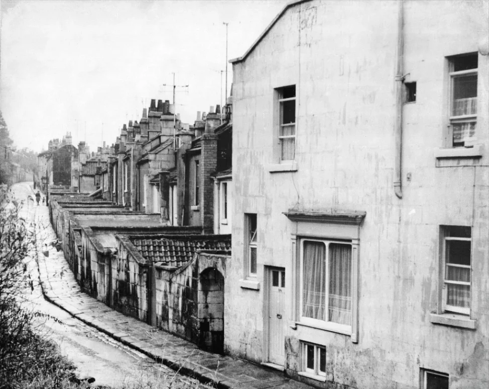
Upper Trafalgar Place in 1965. Courtesy of Bath in Time.
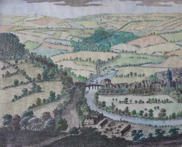
Detail from ’South East Prospect of Bath’ 1734 by S & N Buck. Courtesy of Bath in Time
Until only recently (eg 1952 OS map) Holloway was referred to as ‘The Fosse’ or ‘Fosse Way’, identifying it as the Roman road which ran from Lincoln to Exeter; it is now thought that Fosse Way split at Odd Down, one part going down to a ford at Twerton, the other down to a bridge in Bathwick. Being the main southerly road from Bath, a variety of buildings would have lined Holloway over the centuries and in medieval times wool merchants were said to have had fine dwellings there.
The only historic buildings in Holloway shown in Robins’ picture of 1757 that are left standing comprise: the Chapel of Saint Mary Magdalen (C11th origins) with the adjoining Magdalen House (rebuilt in the Regency period), the nearby Hospital (rebuilt in 1761) and Paradise House with its venetian-style windows (built ca. 1735).
Holloway Turnpike was established at Bear Flat in the mid-1770s at the summit of the newly constructed Wells Road, nearby the Bear Inn and Holloway Brewery. In 1793 the trustees of the Bath Turnpike Roads called a meeting to consider an extra toll for wagons carrying quarried stone that were causing excessive damage to the road surfaces.
Today Holloway extends only as far as Hayes Terrace and the shopping parade of Bear Flat, but up until the 1880s ‘Holloway’ extended up to where the Wells Road and Bloomfield Road split, hence the naming of Holloway Farm (site of the Bath & West of England showground in 1877) and the Holloway Fair.
Holloway Fair was held originally as part of the religious calendar on the day of the “Feast of the Invention (or Discovery) of the Holy Cross” in May. The Abbey Prior gave permission for it to be held on land at Bear Flat and beyond, deriving a modest annual income. The Fair continued to be held after the dissolution of the monasteries and the income may have been endowed to St Mary’s Chapel. It became very popular in the C18th for the sale of livestock and produce and particularly when a horse fair was added in 1754. It was during this time that the Fair gained a reputation for drunkenness and brawling, much to the dismay of those concerned with attracting genteel society to the city. In the C19th the Fair waned in popularity such that in 1839 Reverend Tyte described it comprising merely of ‘two ginger-bread stalls and a swing boat’.
St. Mary Magdalen Chapel
In the late 11th century Walter Hussey (Hosate) gave his house and adjoining domestic chapel of St Mary Magdalen to Bishop John of Tours and the cathedral at Bath. Bishop John is thought to have used Walter’s gift to establish one of the earliest chapels in the country for the particular care of lepers who came to Bath hoping to be cured by taking the waters. Magdalen House, which was rebuilt during the Regency period and is attached to the west end of the chapel, is the likely site of the original hospital.
Over the following years St Mary’s suffered from periods of poor administration, leading to successive declines in fortune and campaigns for rebuilding. In 1495 Prior Cantlow carried out a major restoration of the property, some parts of which are visible today. In the late 16th century, land associated with the chapel (30 acres in 1535) had to be leased out in order to pay debts and it was around this period that the hospital ceased to serve lepers, so that by the mid-17th century the hospital was involved in the care of ‘lunatics’.
In 1760, Bath’s then Rector, Duell Taylor, undertook the repairs to the chapel so as to cater for the increasing number of parishioners living in the area, and in 1761 the thatched cottage which then served as the hospital, just down the hill from the chapel, was completely rebuilt – as the inscription above the front door describes. Further major repairs and alterations to the Chapel were made in the 1820s.
St Mary’s was formerly a chapel within the parish of Lyncombe & Widcombe so its registers are to be found with those of the parish church of St Thomas. An index to all the burials at St Mary’s and descriptions of the surviving monuments can be found at the Bath Record Office or online at www.batharchives.co.uk/cemeteries/st-thomas-à-becket-and-st-marks-widcombe.
A full history of St John’s Hospital and St Mary Magdalen has been written by Jean Manco in her beautifully illustrated book ‘The Spirit of Care’ published by St John’s Hospital, Bath.
Holloway’s image
In the past Holloway had a wide variety of small shops and not only five public houses, but also the Holloway Brewery whose owner lived at Paradise House.
In 1891 Peach’s description of Holloway in ‘Bath, Old and New’ is hardly flattering: ‘(the houses) are small, mean and wretched, consisting of petty chandlers shops, dirty pot-houses, slop-sellers residences, etc’. He goes on to say that many of the residents of Holloway earned their livings by begging and preying on those who had come to Bath for their health or for fashion.
Begging in Bath had increasingly become a problem since 1597 when an Act was passed that allowed the free use of the baths to ‘the diseased and impotent poor of England’ but they were forbidden to beg on their journey. Not surprisingly, many unscrupulous people also travelled to Bath on the pretence of taking the curative waters, but spent their time ‘emptying the purses of the charitable and the opulent’. Although the Act was repealed in 1714, the ‘Beggars of Bath’ continued to thrive for more than a hundred years, partly due to the fact that until 1836 the parish of Lyncombe and Widcombe was outside the jurisdiction of the city, but in that year, as a result of the Corporation Reform Act, it was included within the city and a city-wide police force was established.
Although undoubtedly beggars found lodgings in Holloway, the census returns show that the majority of people living there were artisans and shopkeepers; furthermore, Holloway House, the large house up the hill from the Chapel, was the home of an attorney.
Another lost local feature was Holloway Pound, a small enclosure (opposite the car park for Paradise House) for the detention of stray livestock which were only released to their owners after payment of a fee to the nearby St Mary’s Chapel or, after 1857, to the City.
Magdalen Gardens
In 1862 the trustees of Bruton Hospital put up for sale the land at the western end of Beechen Cliff, today known as Magdalen Gardens. It was acquired by Bath City Council and in 1902 was handed over to the Pleasure Grounds Committee ‘to be laid out by them as a public pleasure ground’. This small park was immediately popular with visitors and residents alike as part of their walk up to Alexandra Park and the famous views over the city. The area became a sadly neglected part of Bath until recently when a project to enhance all of Beechen Cliff was initiated by B&NES Parks Department.
The Springs of Holloway
In a deed dating ca. 1230 a city water supply is described that took spring water in a lead pipe from Beechen Cliff (Bitching Clyffe) across the river bridge, along South Street to a cistern or conduit by the South Gate. This supply became known as the ‘Magdalen conduit’ after the hospital adjacent to the source of the springs.
In his Itinerary around England & Wales in about 1535 the antiquary John Leland wrote about his entry to Bath “ I cam doun by a Rokky Hille fulle of fair Springes of Water and on this Rokky Hille is sett a large streate as a Suburbe to the Cyte of Bath and (in) this streat is a chapelle of S. Mary Magdalen”.
Leland further records that “The Cite of Bath is sette booth yn a fruteful and pleasant Botom the which is environid on every side with greate Hilles out of which cum many Springes of pure water that be conveyid by diverse wayes to serve the Cite. Insomuch that Leade beyng made ther at hand many Houses yn the Toune have Pipes of Leade to convey Water from Place to Place”.
Evidence that came to light during the archaeological survey of the new Southgate shopping centre in 2006-9 indicated that the lead distribution pipe in the city was robbed out during the 1640s and possibly rerouted after 1650. At this time maintenance of the water supply was paid for by the City Chamberlain.
However, when the construction of the nearby Somerset and Dorset Joint Railway line in 1872 caused a sharp drop in flows and when, in 1887, the water was found to be contaminated, the public supply from the springs was abandoned. The local underground reservoir (at the end of Calton Gardens) continued to be used to store treated (chlorinated) municipal water for local distribution until the early 1960s.
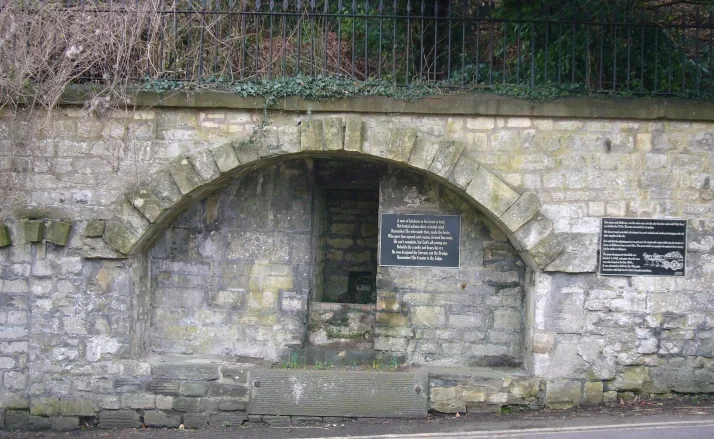
Horse trough in Holloway with descriptive plaques.
An analysis of the 1895 Street Directory for Calton Road Shows that the top ten most frequent occupations of the residents were: mason, labourer, policeman, carpenter, porter, gardener, coachman, tailor, dressmaker, laundress.
The narrow opening at the far side of the house in the foreground led down the steps to St Mark’s Road.
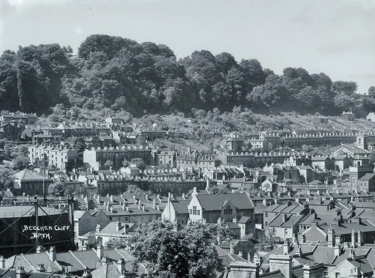
View of Beechen Cliff ca. 1937. Courtesy Bath in Time.
Holloway
One of the most ancient routes serving Bath comes south from the city centre, crosses the river Avon, then ascends the steep western flank of Beechen Cliff via Holloway to reach Bear Flat, before it climbs further to Odd Down, whence routes to the south and south-west lie ahead.
Other than Mr Allen’s stone wharf by the river Avon and scattered houses bordering Holloway as it rises up Beechen Cliff, the scene south of the river in 1734 is overwhelmingly pastoral.
It is generally thought that the name ‘Holloway’ derives from the simple description of a track, worn away by the combination of traffic and flowing water to become a sunken road. Other derivations have been proposed, such as ‘Holy Way’ relating to the pilgrimage route to Glastonbury, or ‘Haul Way’ as used by John Wood the elder, but these derivations are considered unlikely.
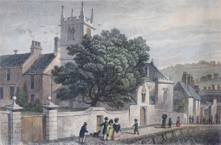
Engraving of ‘St Mary Magdalen’ from a drawing by Thomas Shepherd in 1829
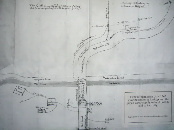
Sketch of spring water supplies from Magdalen Hill, 1745. Courtesy Bath Record Office.
In April 1942 Bath suffered from the ‘Baedeker’ air raids which resulted in serious blast damage to the chapel roof when the houses in Springfield Place opposite were demolished by a direct hit; the roof was entirely rebuilt in 1947.
Today, St Mary Magdalen continues under the administration of St John’s Hospital; services of worship, weddings and baptisms take place in the chapel, as do the occasional musical concerts. The land surrounding the chapel comprises a secluded small burial ground with wonderful views over Bath, plus a delightfully peaceful walled garden full of plants mentioned in the Bible that thrive in the dappled shade of the ancient Judas tree.
Two hundred years after Leland’s visit, the 1745 sketch of spring waters illustrates how the water was collected in upper Holloway, distributed to local outlets and taken by the ‘Great pipe’ across the bridge to supply the south of the city. Around this period, water supply to the city was becoming inadequate, so a new reservoir on Beechen Cliff and a new pipe down Holloway were constructed in 1757.
Ownership of the land where the springs arose was gifted to the trustees of Bruton Hospital in the early 1600s who, until it was put up for sale in 1862, received income from tenants and from users of the water, often referred to as ‘Bruton Water’.
For many years Bath City Corporation operated these spring waters as a public supply, building a series of conduits, collection tanks and distribution pipework to a variety of properties and public standpipes. The C19th census returns show that Holloway and its courtyards had a large number of laundresses capitalising on the ready supply of clean water.
Some spring water continues to flow underground and can always be heard running outside number 12 Holloway as it makes its way into the city drainage system.
Historical views of Bath
Views of Bath from Beechen Cliff have been recorded by painters and photographers for very many years, often with the houses of the Holloway area in the foreground. The following picture illustrate the jumble of housing clinging to the hill as it descends to the river crossing towards the Abbey.
Almost all these buildings have disappeared due to war damage, neglect or demolition prior to redevelopment.
War damage
Holloway suffered significant damage from bombing in 1942, as shown on the map below.
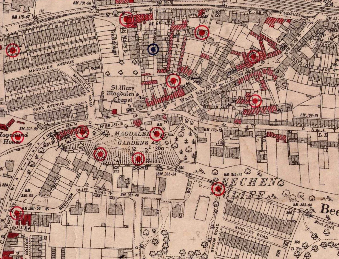
Sites where bombs fell in the Holloway area in April 1942. Courtesy Bath Record Office.
Major Redevelopment 1960 – 1980
Redevelopment of the coloured area was commissioned by Marshman Warren Taylor in the late 1960s; the first of the new houses to be occupied in 1972 were 5-11 Calton Walk, then 15-24 Calton Gardens and 1-6 Alton Place in 1973. The final houses in Holloway and St Mark’s Gardens were finished in the early 1980s by builders M P Kent.
This controversial development replaced all of the, mostly Victorian, housing which had either suffered significant war damage or had fallen into complete disrepair. Note how many ‘ruins’ are marked on the 1952 OS map.
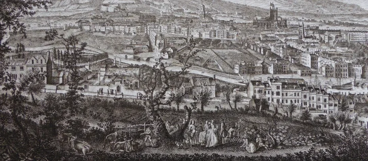
Detail from ‘A South-West Prospect of the City of Bath’ by T Robins 1757. Courtesy of Bath in Time.
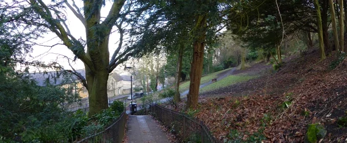
View through Magdalen Gardens onto Holloway.
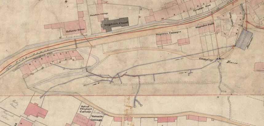
Detail from Cotterell’s map of 1852-54 showing spring water supplies. Courtesy Bath Record Office.
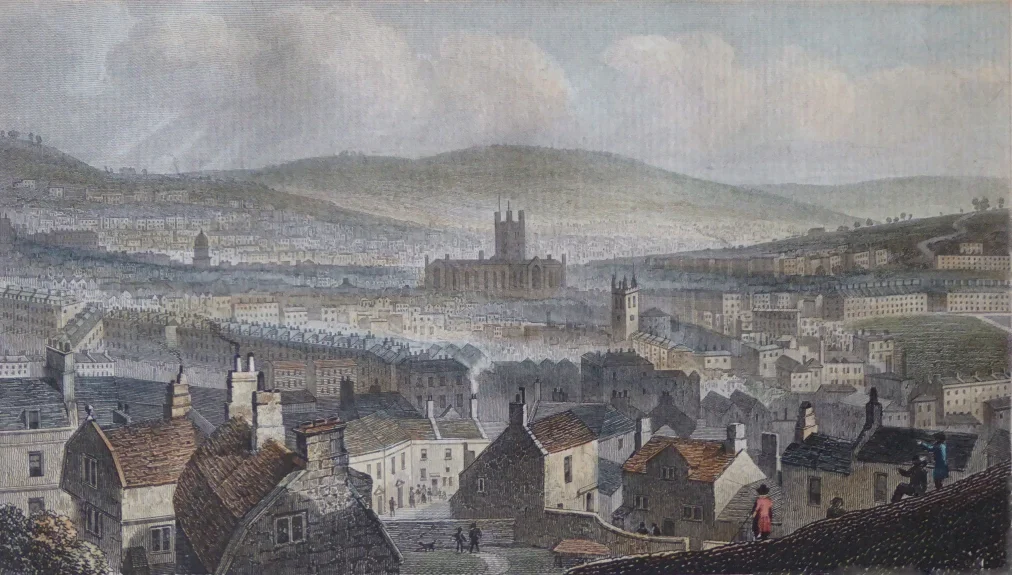
Engraving of Thomas Shepherd’s drawing of ‘Bath from Beechen Cliff’ in 1829.
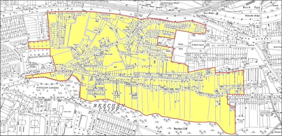
Detail of 1952 OS map showing area redeveloped during the period 1965 to 1980
St Mark’s Road
We are most grateful to WidcombeWest supporter Phil Bendall who compiled most of the following history from his wealth of local research material.
The land where St Mark’s Road was built was part of the area of Lyncombe & Widcombe that was granted by King Edgar to the Priory of Bath in AD 970. The Reformation led to the selling off of the land and, from then until the 19th century, the parcels of land below Beechen Cliff were undeveloped agricultural areas.
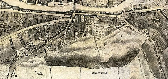
Detail from Harcourt Masters’ map 1795. British Library public domain.
Nearby there had been building of houses from the Old Bridge along Claverton Street. At the lower end of Lyncombe Hill (then Lyncombe Lane) was the site of the first of the parish’s poor houses – built in 1729 – and the house called ‘Pope’s Villa’ at 2 Lyncombe Hill, reputedly named as such because the poet Alexander Pope (1688-1744) stayed there.
The buildings in St Mark’s Road comprise: St Mark’s Church (now a Community Centre), the terraced houses on the southern side, the villas on the northern side and the Temperance Hall.
St Mark’s Church
The land west of the current church was acquired by the parish in 1825, it included a mansion, formerly belonging to the von Luders family, and its garden. The garden was made into the parish’s third burial ground and the mansion into the parish’s new Poor House. In 1826 consideration was given to building a new church for the parish. The church of St Thomas à Becket could accommodate fewer than 100 people. When Ralph Allen developed his quarries, railway, riverside wharf and workers’ housing in Widcombe, he also had to have galleries built in the church for all these new parishioners. It took until 1830 to secure the money to build the new church and it wasn’t until 1832 that it was consecrated by the Bishop of Bath & Wells.
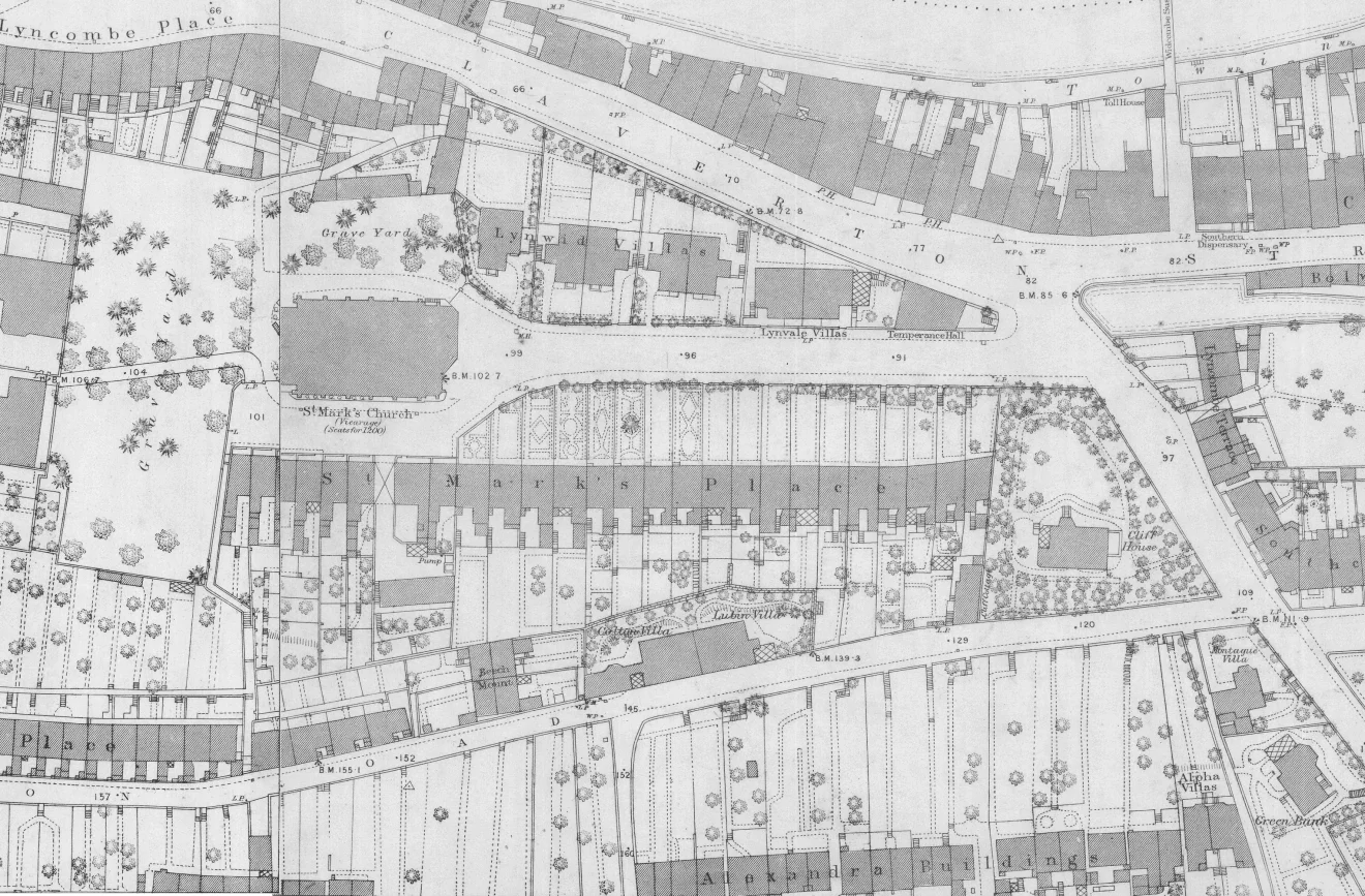
Detail of OS map of 1885 showing St Mark’s Road. Reproduced by kind permission of Bath Record Office.
The church was designed in the Perpendicular Gothic Revival style by Bath City architect George Phillips Manners, who was responsible for designing many religious buildings in the area. Some of the finance came from ‘His Majesty’s Commissioners for the Building of Churches and Chapels’ which had been set up to compete with the rise of nonconformist places of worship. It was intended that there be 1,200 seats, although in practice only about 800 people could be accommodated. Access to the church was via steps from Claverton Street leading to the western door.
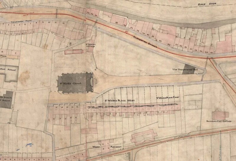
Part of the Cotterell Map of 1852-4 showing the southern terrace and the western access to the church. Reproduced by kind permission of Bath Record Office.
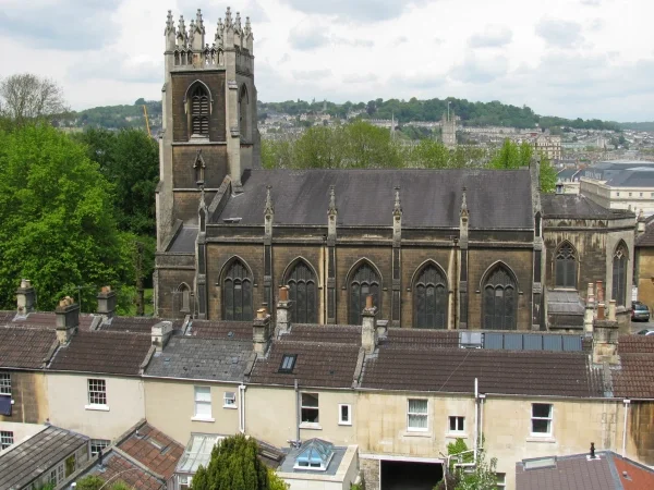
South aspect of St Mark’s Community Centre. Photo courtesy Phil Bendall.
The church was initially considered as a daughter church of St Thomas à Becket; it did not keep its own registers and wasn’t permitted to perform marriages. The rector was the Rector of Bath and the minister in charge was a curate. The parishes of Lyncombe and Widcombe were formally separated in 1856, St Mark’s becoming the parish church of Lyncombe. It was only at this point that the minister in charge was a vicar rather a curate and marriages were allowed to take place in the church.
Of all the seats in the church, 630 were declared to be ‘free’. For the remainder, parishioners could pay a ‘pew rent’ and have their names painted on the end of the pew. The Ebenezer Chapel in Widcombe made a point of all their seating being free. In 1914 the then vicar wrote a letter to parishioners urging them to give up this practice of reserving places by paying a pew rent and to remove their names from the pews “and thus help efface this blot on the worship of God”. He suggested that “If anyone wants any particular seat it is only a question of getting to the church early”.
In History of St Mark’s Church, Bath by Arthur George Cole (1910) the author addresses the issue that the church was built in the wrong place. At the time it was built, “the whole of the residential part of the parish of Lyncombe, lay in the immediate neighbourhood. All of that now densely populated district of Oldfield Park, Hayesfield Park, Bloomfield Gardens and Avenue, and the Beechen Cliff Avenues were all green fields …”. To accommodate the growing population other churches were built: St Matthew’s, Widcombe Hill (1847), St Luke’s, South Lyncombe (1867), Mission Church, Lower Bristol Road (1889) and St Bartholomew’s, West Lyncombe (1893, rebuilt 1938).
The church was closed in 1970s and it now serves as a community centre, run by a dedicated group of volunteer trustees. The centre is well-used by a popular pre-school and other local groups using the main hall and the pleasant tree-lined garden; it also serves as the local polling station during elections.
A comprehensive index of the burials that took place in St Mark’s burial ground is online at the Bath Record Office Online Burial Index listed under Widcombe: https://www.batharchives.co.uk/bath-burial-index
St Mark’s Schools
Two schools, opened in 1856, to the west of the church were associated with St Mark’s; both were closed in 1962. The mixed junior school was demolished to make way for Alton Place, but the infants’ school still stands. The surviving building was used by Bath Technical College and by artists; it is now the premises of a thriving architectural model studio.
The Southern Terrace
The land was owned in the 1700s by the Collibee family and in the early 1800s by Henry Mant who sold the land on which St Mark’s Church was built. In the 1830s and onwards the terraced houses were built progressively to end up with 18 three-storey houses and 8 two-storey houses. Over several decades the terrace was given names St Mark’s Buildings and St Mark’s Place West and East and eventually St Mark’s Road.
In 1838 there were 4 houses, increasing to 12 by the 1841 census, five recorded in St Mark’s Buildings and seven in St Mark’s Place. By the time of the 1851 census there were 19 houses, nos. 1-17 St Mark’s Place plus two without numbers, comprising the two-storey houses at the eastern end and ten of the terrace of three-storey houses.
From the late 1850s to 1864, eight further three-storey houses were added at the eastern end. The 1861 census shows six houses listed as St Mark’s Place East and seventeen houses as St Mark’s Place West. The last house to be built was No. 26 in 1871. This half-sized house was added onto the western end of the terrace and was occupied for many years by a Mr Barter, gardener, and his family.
An anomaly in the terrace is No. 20 that has two stable doors which lead to outbuildings, which have recently been converted into a dwelling. The house was originally occupied by Henry Stone, a well-sinker and quarry master.
The early rate books show that the houses were owned by the main developer and the original owner of the land. In common with many properties built on the side of Beechen Cliff, they were freehold but subject to a ground rent.
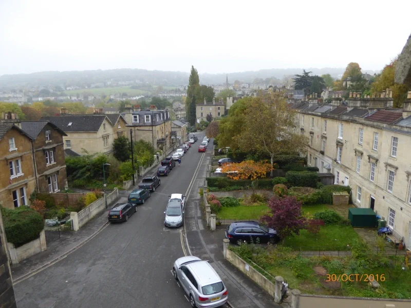
View of St Mark’s Road looking east.
In 1870 there was proposal by the Somerset & Dorset Railway to put a railway line from Green Park Station through Oldfield Park and then into a tunnel under Beechen Cliff. In the end another route was chosen, otherwise St Mark’s Road would have been between two railway lines.
The Villas
The seven residences on the northern side of the road comprise: nos. 1 and 2 Lynvale Villas and nos. 1-5 Lynwid Villas. These were built by Henry Stone around 1870, the well-sinker and quarry master living in St Mark’s Road. Lynvale Villas originally had gabled roofs but by 1895 these had been converted into mansard roofs making them into four-storey houses.
Some of the houses in Lynwid Villas were occupied by members of Henry Stone’s family.
The Temperance Hall - now Tempo Escape Rooms
The Bath branch of the Temperance Society was founded in 1838 and operated from different locations until it was decided to build a permanent hall. The Rechabites were another group associated with the Temperance Society in Bath. The Independent Order of Rechabites was founded in 1835 and was so-named after the biblical descendants of Rechab who refused to drink wine or live in houses. The Rechabites also had death and sickness benefit societies.
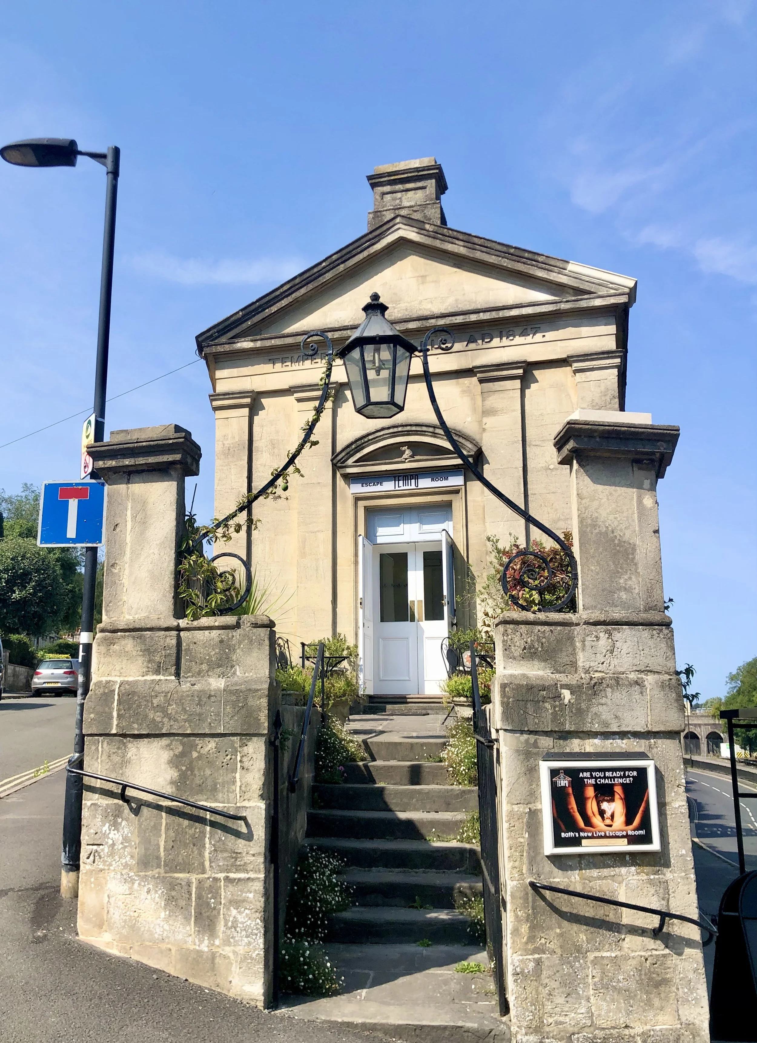
TEMPO - formerly The Temperance Hall, St Mark’s Road
The hall on the corner of Lyncombe Hill and Claverton Street has the year 1847 prominently over the door; the foundation stone was laid on 5 April 1847. The plot of land had once been the site of a toll-house for the turnpike road which had disappeared by the 1830s.
However the building did not remain as a Temperance Hall for long as the Bath Chronicle of 3 May 1849 reported: “On Sunday last, the building hitherto known as the Temperance Hall, in Widcombe, was opened for Divine Worship by the Wesleyan Methodists of this city, when three sermons were preached; … The congregations were large.” (The Methodists had, in the period 1834-1838, used Ebenezer Chapel in Widcombe, but had given it up due to the cost.) Despite the change of use, the name “Temperance Hall” persisted.
Other than for religious purposes, the hall also served as a place for exhibitions, political club meetings and as a polling station. By 1895, the place was no longer in the list of Wesleyan places of worship. In 1904 the Bath Temperance Association, which still owned the building, applied for a music and dancing licence. There were a series of winter musical performances arranged by the association, these being accompanied by temperance addresses.
In 1930 the hall was used by the Elim Foursquare Gospel Church for three weekday evening services. A notice in the Bath Chronicle of 3 June 1939 invited boys wishing to join the Air Defence Cadets to be at the Temperance Hall, Widcombe “to be medically examined and fill in enrolment forms”. In 1945 the hall was acquired by a group of Wesleyan Evangelists who redecorated it and re-named it “Calvary Hall”.
It then became the First Church of Christ, Scientist. In 2020 the church consolidated their congregations and sold the Temperance Hall to some local residents who have reimagined it as Tempo Escape Room.
Alexandra Road
From their lofty position on the slope of Beechen Cliff, properties in Alexandra Road and the adjacent houses of Calton Road that share road access, enjoy splendid views over Bath city.
Development began in the early 1830s and Cotterell’s map shows that in the early 1850s properties in Calton Road were well-established, but what was to become Alexandra Road was simply a track off Calton Road serving the isolated Mount Pleasant and Woodland Cottages, then linking to the ancient path that leads to the top of Beechen Cliff. The road link to Lyncombe Hill was made during the 1860s, so that by 1871 the Census entry for Alexandra Road shows 33 plots for houses: 25 occupied, 6 built but unoccupied and 2 yet to be built; by 1885 the whole road was developed.
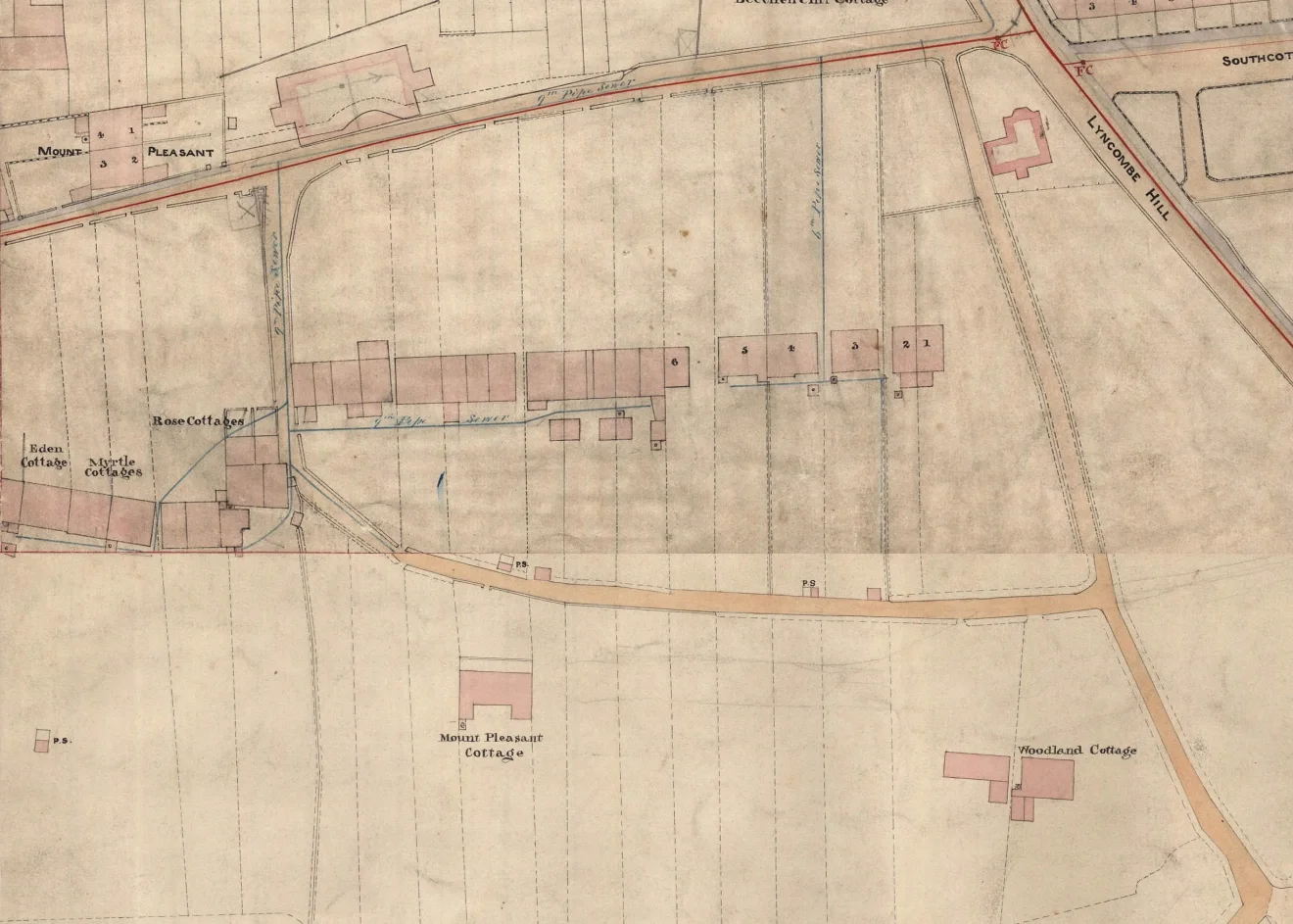
Part of Cotterell’s map c. 1852. Reproduced by kind permission of Bath Record Office.
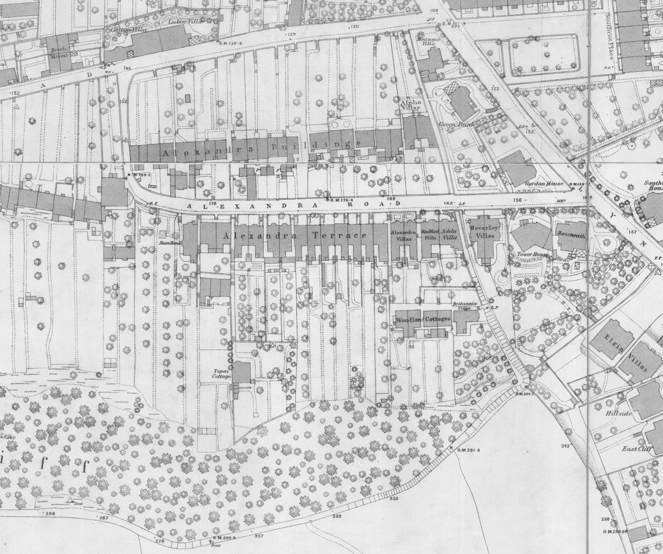
Alexandra Road in 1885. Reproduced by kind permission of Bath Record Office.
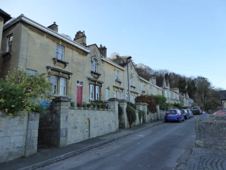
The imposing mid-Victorian terrace of 14-20 Alexandra Road.
The only major changes to the buildings since 1885 has been the replacement of 10-21 Calton Road (shown as Alexandra Buildings) by houses built in the 1970s that are now numbered as 40-49 Alexandra Road, plus the building of three modern houses at the west end of the road. The ‘cottages’ high on the cliff above the villas, that are accessible only off the steep steps leading to Alexandra Park, are being renovated (Jan 2017).
Further local information
For those wanting to delve further into the past, a well-illustrated and wide-ranging ‘History of St Mark’s Road and Near Surroundings’ was compiled by Ann Wyatt in 1997 for the Widcombe and Lyncombe Local History Society.
A detailed architectural description of St Mark’s Church (listed as Widcombe Community Centre) can be found on the Historic England website under List Entry Number: 1394877.
A ‘History of St Mark’s Church, Bath’ by Arthur George Cole (1910) is available online at the Bath Record Office Burial Index website.
St Mark’s Road
We are most grateful to WidcombeWest supporter Phil Bendall who compiled most of the following history from his wealth of local research material.
The land where St Mark’s Road was built was part of the area of Lyncombe & Widcombe that was granted by King Edgar to the Priory of Bath in AD 970. The Reformation led to the selling off of the land and, from then until the 19th century, the parcels of land below Beechen Cliff were undeveloped agricultural areas.
Detail from Harcourt Masters’ map 1795. British Library public domain.
Nearby there had been building of houses from the Old Bridge along Claverton Street. At the lower end of Lyncombe Hill (then Lyncombe Lane) was the site of the first of the parish’s poor houses – built in 1729 – and the house called ‘Pope’s Villa’ at 2 Lyncombe Hill, reputedly named as such because the poet Alexander Pope (1688-1744) stayed there.
The buildings in St Mark’s Road comprise: St Mark’s Church (now a Community Centre), the terraced houses on the southern side, the villas on the northern side and the Temperance Hall.
St Mark’s Church
The land west of the current church was acquired by the parish in 1825, it included a mansion, formerly belonging to the von Luders family, and its garden. The garden was made into the parish’s third burial ground and the mansion into the parish’s new Poor House. In 1826 consideration was given to building a new church for the parish. The church of St Thomas à Becket could accommodate fewer than 100 people. When Ralph Allen developed his quarries, railway, riverside wharf and workers’ housing in Widcombe, he also had to have galleries built in the church for all these new parishioners. It took until 1830 to secure the money to build the new church and it wasn’t until 1832 that it was consecrated by the Bishop of Bath & Wells.
Detail of OS map of 1885 showing St Mark’s Road. Reproduced by kind permission of Bath Record Office.
The church was designed in the Perpendicular Gothic Revival style by Bath City architect George Phillips Manners, who was responsible for designing many religious buildings in the area. Some of the finance came from ‘His Majesty’s Commissioners for the Building of Churches and Chapels’ which had been set up to compete with the rise of nonconformist places of worship. It was intended that there be 1,200 seats, although in practice only about 800 people could be accommodated. Access to the church was via steps from Claverton Street leading to the western door.
Part of the Cotterell Map of 1852-4 showing the southern terrace and the western access to the church. Reproduced by kind permission of Bath Record Office.
South aspect of St Mark’s Community Centre. Photo courtesy Phil Bendall.
The church was initially considered as a daughter church of St Thomas à Becket; it did not keep its own registers and wasn’t permitted to perform marriages. The rector was the Rector of Bath and the minister in charge was a curate. The parishes of Lyncombe and Widcombe were formally separated in 1856, St Mark’s becoming the parish church of Lyncombe. It was only at this point that the minister in charge was a vicar rather a curate and marriages were allowed to take place in the church.
Of all the seats in the church, 630 were declared to be ‘free’. For the remainder, parishioners could pay a ‘pew rent’ and have their names painted on the end of the pew. The Ebenezer Chapel in Widcombe made a point of all their seating being free. In 1914 the then vicar wrote a letter to parishioners urging them to give up this practice of reserving places by paying a pew rent and to remove their names from the pews “and thus help efface this blot on the worship of God”. He suggested that “If anyone wants any particular seat it is only a question of getting to the church early”.
In History of St Mark’s Church, Bath by Arthur George Cole (1910) the author addresses the issue that the church was built in the wrong place. At the time it was built, “the whole of the residential part of the parish of Lyncombe, lay in the immediate neighbourhood. All of that now densely populated district of Oldfield Park, Hayesfield Park, Bloomfield Gardens and Avenue, and the Beechen Cliff Avenues were all green fields …”. To accommodate the growing population other churches were built: St Matthew’s, Widcombe Hill (1847), St Luke’s, South Lyncombe (1867), Mission Church, Lower Bristol Road (1889) and St Bartholomew’s, West Lyncombe (1893, rebuilt 1938).
The church was closed in 1970s and it now serves as a community centre, run by a dedicated group of volunteer trustees. The centre is well-used by a popular pre-school and other local groups using the main hall and the pleasant tree-lined garden; it also serves as the local polling station during elections.
A comprehensive index of the burials that took place in St Mark’s burial ground is online at the Bath Record Office Online Burial Index listed under Widcombe: https://www.batharchives.co.uk/bath-burial-index
The Temperance Hall - now Tempo Escape Rooms
The Bath branch of the Temperance Society was founded in 1838 and operated from different locations until it was decided to build a permanent hall. The Rechabites were another group associated with the Temperance Society in Bath. The Independent Order of Rechabites was founded in 1835 and was so-named after the biblical descendants of Rechab who refused to drink wine or live in houses. The Rechabites also had death and sickness benefit societies.
St Mark’s Schools
Two schools, opened in 1856, to the west of the church were associated with St Mark’s; both were closed in 1962. The mixed junior school was demolished to make way for Alton Place, but the infants’ school still stands. The surviving building was used by Bath Technical College and by artists; it is now the premises of a thriving architectural model studio.
The Southern Terrace
The land was owned in the 1700s by the Collibee family and in the early 1800s by Henry Mant who sold the land on which St Mark’s Church was built. In the 1830s and onwards the terraced houses were built progressively to end up with 18 three-storey houses and 8 two-storey houses. Over several decades the terrace was given names St Mark’s Buildings and St Mark’s Place West and East and eventually St Mark’s Road.
In 1838 there were 4 houses, increasing to 12 by the 1841 census, five recorded in St Mark’s Buildings and seven in St Mark’s Place. By the time of the 1851 census there were 19 houses, nos. 1-17 St Mark’s Place plus two without numbers, comprising the two-storey houses at the eastern end and ten of the terrace of three-storey houses.
From the late 1850s to 1864, eight further three-storey houses were added at the eastern end. The 1861 census shows six houses listed as St Mark’s Place East and seventeen houses as St Mark’s Place West. The last house to be built was No. 26 in 1871. This half-sized house was added onto the western end of the terrace and was occupied for many years by a Mr Barter, gardener, and his family.
An anomaly in the terrace is No. 20 that has two stable doors which lead to outbuildings, which have recently been converted into a dwelling. The house was originally occupied by Henry Stone, a well-sinker and quarry master.
The early rate books show that the houses were owned by the main developer and the original owner of the land. In common with many properties built on the side of Beechen Cliff, they were freehold but subject to a ground rent.
View of St Mark’s Road looking east.
In 1870 there was proposal by the Somerset & Dorset Railway to put a railway line from Green Park Station through Oldfield Park and then into a tunnel under Beechen Cliff. In the end another route was chosen, otherwise St Mark’s Road would have been between two railway lines.
The Villas
The seven residences on the northern side of the road comprise: nos. 1 and 2 Lynvale Villas and nos. 1-5 Lynwid Villas. These were built by Henry Stone around 1870, the well-sinker and quarry master living in St Mark’s Road. Lynvale Villas originally had gabled roofs but by 1895 these had been converted into mansard roofs making them into four-storey houses.
Some of the houses in Lynwid Villas were occupied by members of Henry Stone’s family.
TEMPO - formerly The Temperance Hall, St Mark’s Road
The hall on the corner of Lyncombe Hill and Claverton Street has the year 1847 prominently over the door; the foundation stone was laid on 5 April 1847. The plot of land had once been the site of a toll-house for the turnpike road which had disappeared by the 1830s.
However the building did not remain as a Temperance Hall for long as the Bath Chronicle of 3 May 1849 reported: “On Sunday last, the building hitherto known as the Temperance Hall, in Widcombe, was opened for Divine Worship by the Wesleyan Methodists of this city, when three sermons were preached; … The congregations were large.” (The Methodists had, in the period 1834-1838, used Ebenezer Chapel in Widcombe, but had given it up due to the cost.) Despite the change of use, the name “Temperance Hall” persisted.
Other than for religious purposes, the hall also served as a place for exhibitions, political club meetings and as a polling station. By 1895, the place was no longer in the list of Wesleyan places of worship. In 1904 the Bath Temperance Association, which still owned the building, applied for a music and dancing licence. There were a series of winter musical performances arranged by the association, these being accompanied by temperance addresses.
In 1930 the hall was used by the Elim Foursquare Gospel Church for three weekday evening services. A notice in the Bath Chronicle of 3 June 1939 invited boys wishing to join the Air Defence Cadets to be at the Temperance Hall, Widcombe “to be medically examined and fill in enrolment forms”. In 1945 the hall was acquired by a group of Wesleyan Evangelists who redecorated it and re-named it “Calvary Hall”.
It then became the First Church of Christ, Scientist. In 2020 the church consolidated their congregations and sold the Temperance Hall to some local residents who have reimagined it as Tempo Escape Room.
Alexandra Road
From their lofty position on the slope of Beechen Cliff, properties in Alexandra Road and the adjacent houses of Calton Road that share road access, enjoy splendid views over Bath city.
Development began in the early 1830s and Cotterell’s map shows that in the early 1850s properties in Calton Road were well-established, but what was to become Alexandra Road was simply a track off Calton Road serving the isolated Mount Pleasant and Woodland Cottages, then linking to the ancient path that leads to the top of Beechen Cliff. The road link to Lyncombe Hill was made during the 1860s, so that by 1871 the Census entry for Alexandra Road shows 33 plots for houses: 25 occupied, 6 built but unoccupied and 2 yet to be built; by 1885 the whole road was developed.
Part of Cotterell’s map c. 1852. Reproduced by kind permission of Bath Record Office.
Alexandra Road in 1885. Reproduced by kind permission of Bath Record Office.
The imposing mid-Victorian terrace of 14-20 Alexandra Road.
The only major changes to the buildings since 1885 has been the replacement of 10-21 Calton Road (shown as Alexandra Buildings) by houses built in the 1970s that are now numbered as 40-49 Alexandra Road, plus the building of three modern houses at the west end of the road. The ‘cottages’ high on the cliff above the villas, that are accessible only off the steep steps leading to Alexandra Park, are being renovated (Jan 2017).
Further local information
For those wanting to delve further into the past, a well-illustrated and wide-ranging ‘History of St Mark’s Road and Near Surroundings’ was compiled by Ann Wyatt in 1997 for the Widcombe and Lyncombe Local History Society.
A detailed architectural description of St Mark’s Church (listed as Widcombe Community Centre) can be found on the Historic England website under List Entry Number: 1394877.
A ‘History of St Mark’s Church, Bath’ by Arthur George Cole (1910) is available online at the Bath Record Office Burial Index website.
Lower Wells Road
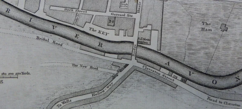
Detail of Hibbart’s map of 1786. Reproduced by kind permission of Bath Record Office.
Wells Road was constructed in the 1770s in order to provide a gentler gradient than steep Holloway for traffic between Bath city centre and the Holloway turnpike at Bear Flat to the south.
The map below outlines a scheme in the 1820s which would have changed the area considerably. It aimed to prevent severe flooding by straightening the course of the Avon and extending the junction with the canal west of the town centre, but the scheme was not pursued.
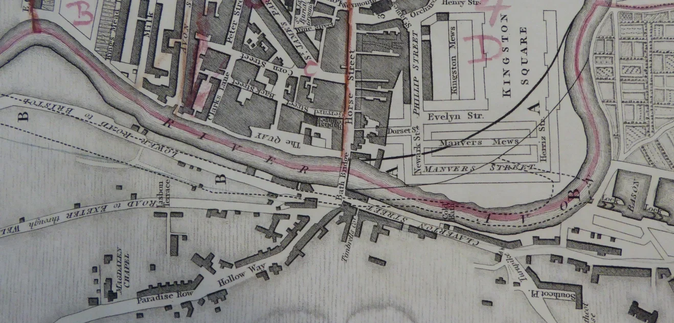
Detail from map of 1816. Reproduced by kind permission of Bath Record Office.
Development between Lower Bristol Road and Wells Road was curtailed soon after by the construction of Brunel’s GWR railway viaduct during the latter half of the 1830s, the line to Bristol being opened in August 1840.
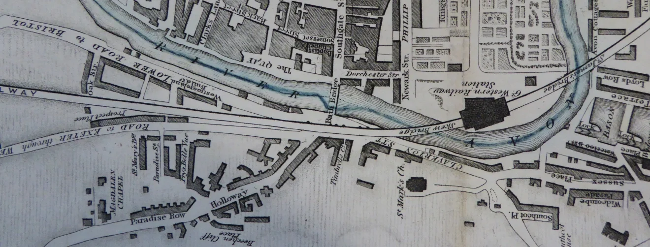
Detail from Godwin’s map of 1843. Reproduced by kind permission of Bath Record Office.
The group of buildings on the north side of lower Wells Road, now mostly residential, were built during the 1830s. The small lower terrace was known as Angel Terrace and nos. 16-48 were named Prospect Buildings, originally a row of small shops and dwellings.
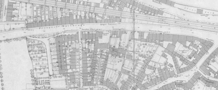
Detail of the OS map of 1885 showing the lower Wells Road area. Courtesy Bath Record Office.
Paradise Street, built to the east side of St Mary’s Buildings, linked Old Orchard (now roughly where the Holloway cul de sac is) to Wells Road. In 1961 eight of the original twenty houses were occupied, but by 1971 this number had dropped to only two: demolition soon followed.
The most modern building in the area today is the steel-clad commercial unit that houses the Action on Hearing Loss workshop and gift shop, plus the ever-enticing Great Western Wine outlet.
Today’s woodland scarp on the south side of lower Wells Road was created in the mid-1960s when Lisbon Terrace (bomb damaged), Paradise Place, Somerset Place and Warwick Place were demolished to accommodate the new route of Wells Road.
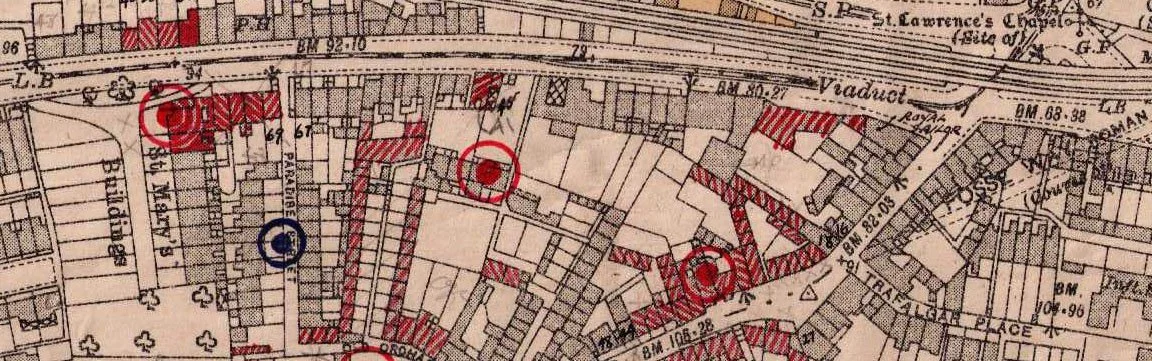
Detail of bomb hits in 1942. Reproduced by kind permission of Bath Record Office.
Red circle shows exploded bomb, Blue circle represents unexploded bomb.
St Mary’s Buildings
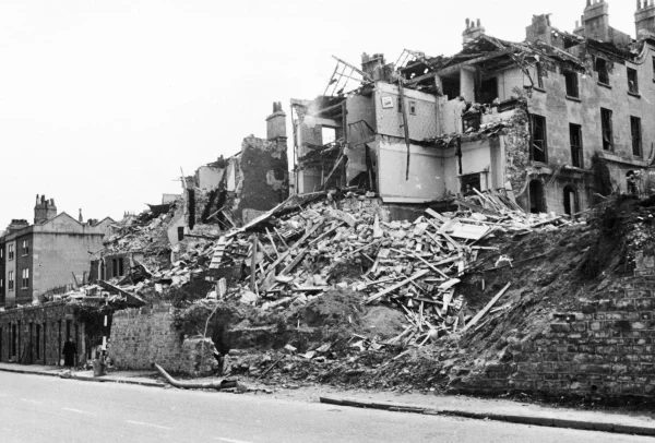
Bomb damage to St Mary’s Buildings & Lisbon Terrace in 1942. Courtesy of Bernard Thomason.
The area between Holloway and Wells Road, comprising Park Avenue, Magdalen Road and Magdalen Avenue, was developed in the early 1900s, as were the terraced houses of 77 to 117 Wells Road. Holloway House was demolished to make way for access to the development off Holloway on land formerly belonging to the house extending down to Wells Road. One of the large stone entrance posts to Holloway House, now part of the Chapel garden wall, is all that remains.
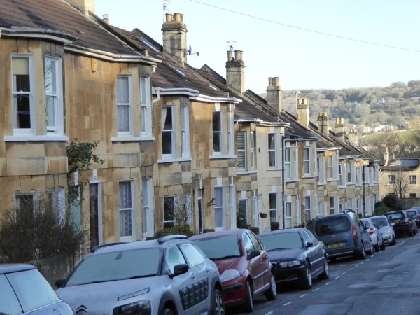
Magdalen Avenue terrace
Some rebuilding had to be done after the air raid damage in 1942. The flats at nos. 26-28 Wells Road used to be The Railway public house that closed in the 1990s due to falling trade. Formerly it had got much of its trade from people working at premises in the Lower Bristol Road who used the rear entrance to the pub for quick access.
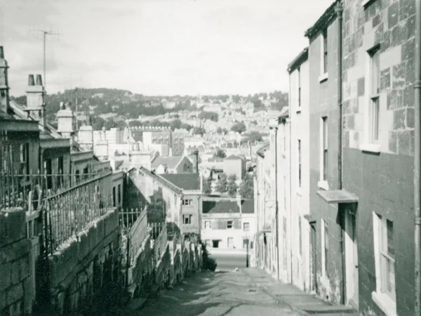
View down Paradise Street to Wells Road in mid 1960s. Courtesy of Bath in Time.
St Mary’s Buildings, in a private road sheltered by trees from the busy Wells Road, were built in about 1820 and attributed by some to John Pinch. The nine houses form a delightful terrace with linked, sweeping cornices that complement the elegant proportions of this late-Georgian gem. At a casual glance it is difficult to see that houses 1 to 3 were rebuilt after major bomb damage in 1942.
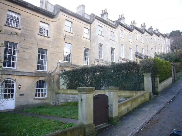
St Mary’s Buildings today; built ca 1820, attributed to John Pinch.
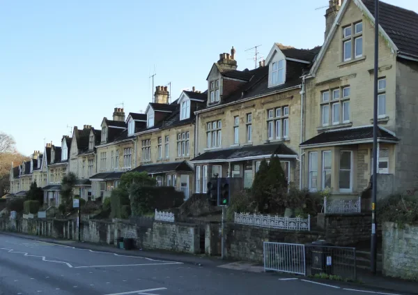
Lower Wells Road terrace
In 1972 the western extent of the Widcombe Parish boundary was revised when St Mark’s Church was closed. Today the boundary runs to the immediate west of numbers 9 and 30 Park Avenue, numbers 21 and 22 Magdalen Avenue and number 117 Wells Road, whence it runs in a straight line due north to the south bank of the Avon.